What is the Equator Line - The Complete Information

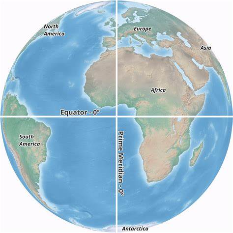
The imaginary line drawn on the globe from west to east joining the points located on the equatorial bulge farthest from the center of the Earth is called the equator.
This line divides the Earth into northern and southern hemispheres.
When was the Equator discovered?
The Equator was discovered and mapped by a French geological explorer named Charles-Marie de La Comdamine in the year 1736.
In the system of latitude and longitude, the equator is the line at 0° latitude. Its circumference is approximately 40,075 kilometers (24,901 mi). At the equator, day and night are equal throughout the year, hence it is also called the equator.
The Earth's Equator is the line that divides the world into the Northern Hemisphere and the Southern Hemisphere.
You may love to read this: Latitude and Longitude
What Countries are on the Equator Line?
The Equator line passes through 13 countries:
- Ecuador
- Colombia
- Brazil
- Sao Tome and Principe
- Gabon
- Republic of the Congo
- Democratic Republic of the Congo
- Uganda
- Kenya
- Somalia
- Maldives
- Indonesia
- Kiribati
How many continents pass through the Equator Line?
The equator passes through three continents: Asia, Africa, and South America.
Climate at Earth's Equator
Countries near the equator do not have four seasons like other places on Earth. Due to the spherical shape of the Earth, the sun's rays fall directly and concentrated on the equator, due to which the temperature remains high there. Another reason for the equator being hot is that due to the Earth's natural bulge, the equator is closer to the Sun than anywhere else. Due to these reasons, there is extreme heat throughout the year at the equator.
In countries located on or near the equator has 12-hour day and night.
What is the importance of the equator?
The equator divides the Earth's surface into two equal hemispheres. The equator has a significant impact on the climate of the countries through which it passes. Typically, the climate in such countries is tropical – hot and humid. This is because this line lies in the middle of the Earth's surface and thus these countries receive direct sunlight for most of the day.
Why are day and night equal in the equator?
Since the sun's rays fall first on the equator, day and night are equal throughout the year at the equator because it is not tilted with respect to the sun's location.
India and Equator Line
The entire area of India falls in the northern part of the equator. The total distance between the Equator and the landmass of India is 876 kilometers or 544.32 miles.
Interesting facts about the equator
The name Equator comes from the Latin word Equator which means circle equalizing day and night.
The highest point on the equator is Volcán Cayambe in Ecuador at 4,690 metres.
The Equator is located between the North Pole and the South Pole at 0 degrees latitude.
The closer a place is to the equator, the warmer its climate.
Panaji (capital of Goa) in India is closest to the Equator Line.
You may also like:
The story of IIT Village of Bihar
Over 40 students from Bihar's Patwa Toli have cleared JEE Main 2025, with many trained at a free coaching centre run ...
Top Career Options After 12th: Courses, Exams, Colleges, Fees & Salary Packages
Explore top career options with detailed information on entrance exams, admission process, top co...
